

I’m currently working on the Stuarts so am enjoying a break in sunny Scotland – a continuation, if you will, of the Mary Queen of Scots world tour upon which I intermittently indulge. So yesterday we joined some camels for breakfast off the A66 before heading in the direction of Hadrian’s Wall. There was a pause at Corbridge so that I can re-photo the Vicar’s Pele in the churchyard of St Andrew’s. Once upon a time, the vicar during time of trouble between England and Scotland the vicar would shut himself into the defensive building and hope for the best. It was built in the fourteenth century just at the point when the wars of independence were warming up. Its builders used dressed stone from Coriosopitum Roman camp known locally as Coria and by the modern world as Corbridge.
So far so good but I must admit to being slightly bewildered to seeing the street name Watling Street. For a moment I thought I’d got things very badly wrong over the years. I thought the famous Roman Road started in Kent made its way to St Albans and then cut across country towards Wroxeter. By the ninth century it was effectively the border between the Saxons and Scandinavian ruled Danelaw. So why does a short stretch of Watling Street suddenly turn up in Corbridge in Northumberland?
The answer is that the Romans did not build a small extension to the road in Northumberland. Dere Street Stretches from York north into Scotland (quite some way beyond Hadrian’s Wall) up to the Antonine Wall. Error arose because of the written record. The Antonine Itinerary which was created during the Roman period and which was reproduced by the Anglo-Saxons between the seventh and tenth centuries is a good example of the way confusion could arise. It was basically a road map of the Roman Empire with a British section. The second route listed in the British part of the itinerary misidentified a route between York and Carlisle as Watling Street. And by the Middle Ages short stretches of Roman Roads were being called Watling Street whether it was accurate or not. You can find a Watling Street from Catterick to York; from Knaresborough to Ilkley; there’s an example in Preston; and of course – the proudly named section of Dere Street in Corbridge.
And yes – we stopped off in a very misty and damp Corbridge Roman town to have a look at the Corbridge hoard which was buried during the second century AD and which was rediscovered in 1964. The Roman segmented armour is the star turn of the hoard which is thought to have been buried for safekeeping by a smith but there are also leather and textile artefacts. Until its discovery no one quite knew how the armour was manufactured. The museum also boasts a dodecahedron, an artefact that is something of a mystery because no one has yet established what its purpose was.


Then it was on to Otterburn, the site of the battle in 1388 between the Scots and the English – for an account look at Froissart but don’t expect to find a photograph of the site here. By the time we arrived it was like wondering around inside a very damp cloud and I fully expected to become lost. We stopped at the mill shop to see if I could find a waterproof that actually is waterproof and I was pleased to find a field full of tenterhooks so it wasn’t all in vain.

Thankfully we made our way to our overnight accommodation without mishap and were shown to the ‘wobbly room’ which proved an apt description of the floor. Much to my delight I was staying in a pele tower – something I’ve always wanted to do. This particular one, at Clennell, was a bit like the little doll in the middle of a set of Russian dolls. Like the Vicar’s Pele it was built during the fourteenth century. It may have evolved into something slightly more comfortable by 1567 but the emphasis would still have been on defence. A new range was added in the seventeenth century around the original building and then more additions were made in the eighteenth and nineteenth centuries – actually perhaps I should have described the hall as being a bit like a many layered onion. In any event I was delighted by the whole thing.

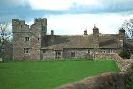
 In 1415 there were about 78 peel or pele towers in Northumberland. These towers were essentially private fortifications for protection in the event of Scottish raids – or neighbours you didn’t necessarily agree with. The idea was that you could secure your family and portable valuables until it was safe to emerge or help arrived – beacons were kept on the top of the towers which could be lit to summon help and to worn the surrounding countryside of danger.
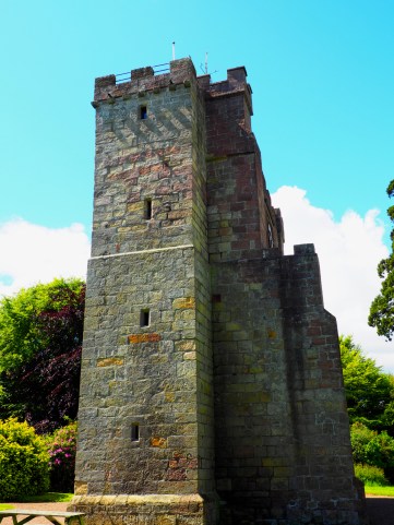
 Hervey Fitzmaurice once owned the Manor of Dalston just south of Carlisle and with it, Rose Castle at Raughton Head, these days the location of several pleasant walks.
 Pele or peel towers are a peculiarity of the Anglo-Scottish borders. They came into existence in a medieval environment, largely during the Scottish Wars of Independence, when the population lived in fear of constant attack. Really and truly none should still be standing as when James VI of Scotland became James I of England he decreed that the borders should henceforth be known as the “Middle Shires” and that pele towers should be torn down. He also executed or deported men with the most notorious border surnames, both English and Scots, to drive his message home.
 It’s a two-storey tower with a vaulted undercroft and like some of the rather grander pele towers it was extended once England and Scotland ceased raiding one another and windows inserted – so technically it ceased being a fortification and turned into a rather grand farm house. In this instance the extension is a seventeenth century one.